
Technically Winter ceases on the 31st of August. Nature knows differently with trees already in full bloom and the days being a bit longer, a bit warmer. Still the weather is a curious beast and many a person has made a career on trying to understand it!

The weekend of the 27th / 28th of August was forecast to be fine with Sunday now being the nicest day for a trip out. During the week had been cold and wet with snow down to low levels before fining up on Friday. The extra day should help to dry the bush out a bit.
Sunday 28th of August 6:30 AM. Our intrepid 80 Series landcruiser heads out on another adventure. The sky is clear, not overly cold. A good day to be out!

The upper fall of Snobs Creek
One objective for the day was to keep up some training for our USA trip with some reasonable walks but not as strenuous as the 25K in a day effort. Back to an area I know quite well, The Rubicon & Snobs Creek Valley area a couple of hours north east of Melbourne.
First up a return to Pyramid Hill VK3/VN-005. A drive up in all but the winter season where the road is seasonally closed. At this time of year it is simply a case of heading south on Snobs Creek Rd to Number 5 Rd then parking at its junction with Royston Range Tk (Seasonal Road Closure gate just up the track!) Why start off on an easy summit you may well ask?
1. I wanted to determine the altitude of the remaining snow.
2. I was not sure if there would be access (read on…)
3. Pyramid Hill is the first summit along my proposed route.
Well, I half anticipated what ended up happening. There were warning signs along the northern section of Snobs Creek Rd that logging was occurring in the area and that access and roads could be restricted or closed. On walking up the 2wd section of Royston Range Tk I came across a Timber Harvesting Zone with the 4wd track across the Royston Range being definitely off limits. Got to within 500m of the summit too; Bugger! And I was right  on time for my proposed 23:30 hrs utc (9:30 AM) start up. So much for my schedule now!
Plan B
Proceed to Bill Head VK3/VN-004 located a short distance further south along Snobs Creek Rd.
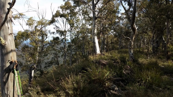
Previously I had accessed Bill Head from the north via Conn’s Gap Rd. This requires a little bit of low range 4WD in a slippery climb from 1180m to 1270m in 600m once past Conn’s Gap. Once at the top of this incline, one is on the highest section of Conn’s Gap Rd; all that is then required is a 200m bash through logging debris and regrowth to 1300m then head south along the spur towards the 1370m Bill Head. Sounds easier than it is and I had never actually made it to the summit, rather calling it quits once inside the activation zone.
This time my access route was from the south, 1.1 km east along Conn’s Gap Rd from its junction with Snobs Creek Rd and Snobs Link Rd. This location is a relatively flat area, plenty of parking and at the start of the spur leading to Bill Head from the north. Altitude about 1130m.
 I got out first to have a look. Some signs of logging, regrowth but not too bad and with reasonable open sections. 2.1km along the spur (all off track) to the summit. with snow from 1300m. Time took was 1hr 20 minutes (9:50 to 11:10 AM). Not sure if it was any quicker but I was at the top this time. A very large, flat and open summit with plenty of choice as to where to activate from.
That I did not fall over once leads testament that this route is a bit easier. The run along the spur was dead easy but for the snow cover on some sections that created “sink holes” when trodden on.

Operational by 01:24 hrs UTC, Peter VK3PF pounced on my 80m CW call. Not sure if I had a spot out but did have APRS tracking (VK3CAT-13) operational via my SPOT Messenger.
Peter was the only 80m contact, followed by 4 further contacts on 40m CW, 6 om 40m SSB including a (ground wave?) S2S with Mark VK3ASC on VK2/RI-004.
Last contact in the log was Ron VK3AFW on 6m CW, proving that the higher HF and low VHF bands can be a substitute for the now unreliable 40m NVIS.
My descent was via a more direct route. I had intended to run a steep easterly spur down to Conn’s Gap Rd. The direction changed some what when I hit a wall of thick regrowth. The easiest path seemed to be to the north so I took that. This was a real scrub bash, helped with gravity and I took a few tumbles. Definitely not recommended for an ascent. 1370m down to 1220m in under 500 metres. It took 17 minutes.
In retrospect, I should have tried the south side of the spur instead, a 750 metre descent to 1170m but saving 1 kilometre on the road. As it was, it was 4.3 kilometres, 40 minutes of easy road walking back to the car.
Back at the Snobs Creek Road Junction, there is Snobs Link Rd to the east that heads to the main Eildon to Warburton Rd, Bullfight Track to the west (seasonally closed) and Coys Rd to the south (sometimes closed).
I took the open Coys Rd to where it intersects Federation Rd, continued generally south on Federation Rd to the Royston Gap. I continued generally south on (depending on your map) Sandstone Rd or Royston River Rd to the signed junction of Sandstone and Cambarville Rds (Note – if wanting to continue south along Cambarville Rd, a sharp right hand turn is required at this intersection as Sandstone Rd is straight ahead!
Keppel Ridge VK3/VN-006 1104 Metres
8.8km and under 30 minutes from my Conn’s Gap Rd parking spot, I was at an ideal parking spot recommended by Allen VK3ARH on Sandstone Rd and nearly directly adjacent to the summit. Time about 1:40PM.

The off track route to the summit is quite a slog for the most part. Starting off in the gully where the car was parked, I quickly exited both it and the tangly growth to commence a steep ascent of relatively open forest.
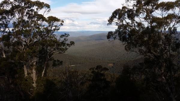
Steep? Starting off at 925 metres, the going is constant to 1070 metres in 450 metres taking 40 minutes. From here it plateaus out to the 1104 metre summit that is located to the north and east on the edge of a near sheer drop into the Torbreck river valley. This last bit is an easy 270 metres and took just 8 minutes.
Got to admit of feeling a little stuffed so took longer than normal to set up.
First in the log was Steve VK7CW on 80m followed surprisingly by Allen VK3ARH (giving Allen a completed summit!)
5 further 40m cw contacts to VK2,3 and 4. Worked VK3s LED & GRK on Mt. Macedon for an 40m SSB S2S plus Warren ZL2AJ (20m SSB) on ZL1/VK-139 plus John ZL1BYZ on 20m cw. Whilst looking for VK6, I again worked Jan OK2PDT (Czech Republic) on 20m CW long path.
Tried in vain to work Ron VK3AFW on 6, 10, 15 or 40 metres. It was now getting cool and time to head off. Last contact was at 05:36 but it was closer to 04:00 hrs utc before I headed back to the car. Roughly following my GPS track, my descent took less than 20 minutes for the 720 metre trek.
A quick cup of coffee and snack, then home by just after 7:00pm with a stop to pick up some takeaway from our favourite Indian Restaurant in Ormond
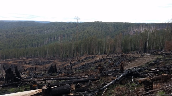
A not so beautiful sight off Cambarville Road
Note to activators: Phone coverage quite good on all summits with the Galaxy S5 phone which is way better than the previous Galaxy Nexus.

Hi Tony
boy o boy you had a bugger of a day I don’t envy you at all.
only consolation is you got some exercise and made it home safely
thanks for the interesting Blog Mate
and catch you on a Summit through Sprin
73 Rod
A great day in the Rubicon Ranges Tony. Thanks for the directions to the Bill Head and Keppell Ridge summits, the navigating notes help those of us who follow. 73 Paul vk3hn.
Hi Tony,
I was watching your progress on APRS….
Posted a Spot indicating that you had aborted Pyramid Hill shortly after receiving your text message.
Followed your progress on APRS to Bill Head and anticipated that you would come up on 80 m CW first, which is what happened. Worked you and posted a new spot. Listened in the background as you called with no replies and heard the QSY message, so posted a new Spot for 40 m CW. You were all OK from there.
From memory, you posted a Spot for Keppel Ridge.
Thanks for the contacts and the write up.
Cheers,
Peter VK3PF
Peter, many thanks for your attention and assistance. Makes life a bit easier. I did not have phone access when in the saddle below Pyramid Hill so trusted the text message would find its way in due course, which it did. Nice to see SPOT was working too. I can use this to send a generic alert message to nominated emails of which you are one.
Paul, information is king and anything that assists other activators is a worthwhile effort. I think it was definitely worth taking this alternate route and would certainly recommend it, especially to those that do not have 4WD capability.
Rod, it was actually a pleasant and rewarding day. I did not score the points I had hoped for but no real consequence there. I had thought of going home via Matlock to pick up another 8 pointer but it was getting late in the day and I was a little tired. There are some great summits in this little area, some are drive up, others require a bit more work but fun is in the challenge and the views can be breathtaking.
Heading to the USA and Canada in early September. Have a number of summits planned including a few un-activated ones. The Yosemite National Park, Crater Lake and Mt. Rainier National Park certainly look inspiring.
Catch up when back, Tony.